Before we got to Worthing Pier we walked across Splash Point, an area hailed as one of the most exposed points on the south coast of England (although it doesn’t look it on Google Earth). There is a sea wall here, but without that defence it is estimated that coastal erosion would advance by as much as 2.5 metres every year. To stop this from happening, a massive retaining beam and wall of steel was covered by the concrete sea wall, and then rocks placed around the perimeter. This was all done in 1990, when a Time Capsule was also placed in the heart of the structure. I wonder, if no maintenance were carried out, how many years it would take before the sea would wash everything away and expose the capsule?
On top of the sea wall there are other rocks which have been arranged in a neat cluster on the walkway, interspersed with nozzles which regularly send a fine, light spray into the air. How refreshing!
 Worthing Pier itself was opened in April 1862 and then widened between 1887 and 1889 in celebration of Queen Victoria’s Golden Jubilee. It has suffered the usual pier problems. A storm demolished the decking between the pavilion and the shore on Easter Monday in 1913. The poor, stranded pavilion was given the nickname “Easter Island” until repairs were effected. In 1933 a fire then destroyed most of the pier. It took two years before it was rebuilt, only to be partly demolished on purpose during the war years to prevent the possibility of enemy landings.
Worthing Pier has seen better times recently – it was awarded Pier of the Year by the National Piers Society in 2006! Since 2008 it has hosted the International Birdman Competition, in which competitors hurl themselves off the pier in human-powered flying machines (usually succeeding only to plummet straight into the sea). We were a couple of months early for that, as it takes place in August, attracting some 25,000 spectators.
The pier currently stands at 960 feet long. We got some good views west of the walk yet to come.
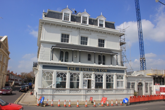
 We carried on that way, soon reaching the hotel we had booked to stay at that night, The Burlington. It had good reviews, none of which mentioned the traffic cones outside, the scaffold on the east flank wall and the large cranes stood next to it – next door was a building site! We surveyed all of this and decided to keep walking for the time being. We turned and continued on our way west.
Points on this part of the walk (copy and paste the co-ordinates into Google Earth):
- Splash Point: N 50° 48.615 W 000° 21.845
- Worthing Pier: N 50° 48.450 W 000° 22.140
- Burlington Hotel: N 50° 48.488 W 000° 22.927
Walk #54 Statistics (of which this post forms the fifth part):
- Date of Walk: 31 May 2013
- Walk #54 total distance covered: 9.72 miles
- Coast of Britain Walk Total Distance Covered: 445.64 miles
- CLICK HERE FOR LINK TO INTERACTIVE MAP!!!


I see that ice cream has been properly embraced as an Essential Food of Walking. And rightly so.
I’m unable do any serious walking at the moment having foolishly sprained my knee, so your excellent blog has become a kind of vicarious pleasure. And, by implication, also an excuse to eat ice cream for reasons of walking empathy!
Hi Ju – Yes, I saw from your blog that you had to call a temporary halt to your proceedings. I hope your knee is healing well and that you will soon be back on the road. In the meantime, take comfort that the ice cream probably doesn’t melt quite as quickly when it is away from the sun and in your living room… Nic